
General
Although in recent times MULTI has diversified its services into many fields, irrigation sector is the core of its activities. MULTI's involvement in this sector coincides with the introduction of local consulting activities in DOI projects, and has to it's credit experience in most of the irrigation related consulting assignments, executed during the last two decades. During this period, MULTI has witnessed evolvement of several policies and strategies adopted by the executing agencies and shares the responsibility for its success and failures.
Experience with FMIS
MULTI's initial experience with FMIS of Talkulo Khola Hill Irrigation Project (1981), Gunjantar Irrigation Project (1982) and Bhirpani Irrigation Project (1982) was thought provoking in terms of conceptualization of beneficiary participation potentials. Subsequently MULTI was entrusted with detail feasibility study of two noted farmer's managed irrigation projects of terai and hills in the year 1984-85, namely Arjun Khola Irrigation Project and Phalangu Khola Irrigation Project. It was an opportunity to assess project implementation practices involving beneficiary participation in project preparation, implementation, monitoring and operation & maintenance. MULTI was able to identify problems andconstraint to O & M in these FMIS. Arjun Khola I.P. had been duly constructed under EEC financing, in accordance with the proposed recommendations of the study. Accordingly, MULTI utilized experience gained in these projects for Daha Khola Irrigation Project (1988).
Water Use Inventory Study of several districts in Nepal conducted by Water and Energy Commission Secretariat (WECS) was a major step towards identifying the potential of FMIS in Nepal. MULTI was entrusted for the study of six districts and took leading part in emphasizing the study for identification and appraisal of FMIS throughout the country.
With the initiation of the Irrigation Sector Program in February, 1988 HMG/N approach to irrigation development included concerns for : (a) making the irrigation development more cost effective through the adoption of appropriate technologies (b) speeding up implementation through investment in quick results generating small and medium scale irrigation schemes and (c) building indigenous institutional capacity. MULTI executed two projects for detailed feasibility studies namely Melchada Khola Irrigation Project (1989) and Majhgaon Irrigation Project (1989) under ISP/DOI. Besides, it was involved in the project identification, selection, formation of WUAs and pre-feasibility study of several ISP sub-projects in Sankhuwasabha, Terharthum and Jhapa districts of Nepal in the year 1990-91.
MULTI's culmination of its efforts to strengthen WUAs and experience with FMIS, is well exhibited in the recently completed detail feasibility study of one of the largest FMIS (24,000 ha GCA) of the country, namely Rani, Jamara and Kulariya Kulo Irrigation Project. This project executed by IDSP/DOI with the financial assistance of IDA/WB, has been approached under "The Irrigation Policy 1992 of HMG/Nepal". One of the main outcome of the study is recommend actions of measures for strengthening existing institutional framework of WUA, leading to their effective participation in the implementation and O & M of the system.
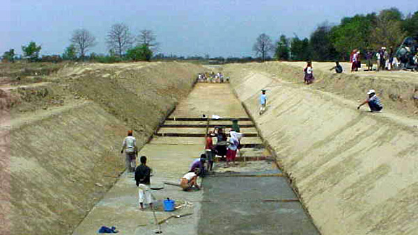
Experience in Public Irrigation System
MULTI had been involved in most of the major public irrigation projects in the country. MULTI's involvement in water management activities of Narayani Irrigation Project and Sunsari Morang Irrigation Project Stage II had given an opportunity to work closely with the WUGs. MULTI's personnel were involved in group formation, training to WUGs, assistance in legalization of WUGs through registration at district offices and preparation of maps and land ownership list for an effective management of irrigation water and possible collection of water tariff. Experience gained by MULTI in some of the major irrigation projects are enlisted as below:
| Saudi Fund for Development Loan No. 5/465: Bagmati Irrigation Project-Remaining Command Area Development Works |
|
Narrative Description of the Project: The Bagmati Irrigation Project is located in the central region of Nepal, and Diverts water from the Bagmati River through diversion Barrage structure located at Karmaiya, Sarlahi district. The project was initially conceptualized as a multipurpose project covering a total irrigable area of 122,000 ha with generation of electric power of 140 MW capacities. The project is implemented in a stage wise development approach in phases. The Phase I development was initiated by government’s own funding resources in 1979, which included the construction of a barrage structure Across Bagmati River at the foothill of the Churia range and eastern and western main canals. The Phase I program was planned in two stages of development packages. The Stage-I of the Phase-1 envisaged to develop irrigation facilities down to tertiary units in 45,600 ha command of Sarlahi (22600 ha) and Rauthat (23,000 ha) districts. The Stage-II of Phase I envisaged to develop 22,400 ha of Bara district. At present Stage-I development works are in progress under SFD funding assistances mainly. Description of Actual Services Provided by your Staff: Primary objectives of the consulting services could be categorized in two kinds of services firstly as assistance mode, and secondly as task mode. The consultants are assisting the client in the project management for regular reporting, contract management, and fiduciary aspects as advisor delivering its expertise services. In the task mode the consultant will support the client for the activities related to; (i) detail survey, planning, and design of 6300 ha CAD works, (ii) detail survey and design of silt ejector, and (iii) parcellary map preparation of 24600 ha irrigated areas, and (iv) construction supervision and quality control works. The consulting team is carrying out the services in the following activities in close consultation and co-ordination with the client Bagmati Irrigation Project. 1. Construction supervision and Quality Control works in the ongoing contract packages. Assisting the project management in project related activities whenever requested. |
| Flood Protection of NZIDP Command Area, WB/HMG, 1989 |
| The main canal and command area Narayani Zone Irrigation Development Project (NZIDP) are frequently damaged during the rainy season because of inadequate drainage facilities and protection from the Bagmati river, Lal Bakeya River and other numerous river. The MULTI carried out the study to assess the flood damage in the area and compute required capacity of drainage channel in order to reduce the flooding problem. |
| Comprehensive Plan for the Protection of Narayani Zone Irrigation Development Project Command Area and River Training of Bagmati and Lal Bakeya River, HMG, 1991 |
| Bagmati and Lal Bakeya rivers are continuously eroding the command area of Bagmati, Manusmara, Narayani and Jhaj Irrigation Project in Sarlahi and Rauthat Districts. The villages located on the banks of the rivers suffer serious bank erosion. MULTI undertook the task of estimating the flood damages and prepare a comprehensive river training works from Nepal-India Border in the south to East West Highway in the north which also included the protection of the tail end of the NZIDP command area and formulate the re-settlement plan of the affected villages. The recommendations include construction of spurs, embankment along the banks of the rivers spread over several phases. The work is under construction since 1991 according to the comprehensive plan. The work constructed in 1991 had satisfactorily withstood two flood season. |
| Topographical Survey and Mapping of Bagmati Irrigation project, HMG 1987 |
| The Bagmati Irrigation Project is estimated to serve 122,000 ha in two Phase development with Phase-I divided into 2 Stages. MULTI provided the consulting services for preparation of topographical maps covering 3035 ha at the scale of 1:5000 with 0.25m contour interval. The work included establishment of survey control monuments. Benchmark survey for vertical control, triangulation for horizontal control and plain table survey for detailed survey; preparation of drawings, benchmark description, traverse observation and schedule of co-ordinate sheets. |
| Bagmati Command Area Development Project |
|
The main objective of the study was to prepare a feasibility report on command area development, suitable for the external financing, covering the gross area of 48,700 ha (Stage-I). The project, financed by Asian Development Bank, was undertaken in association with Nippon Koei and Sir Williams Halcrow & Partners. In addition MULTI provided consulting services for detailed topographical survey of 600 ha sample area and Project Benefit Monitoring and Evaluation study. Feasibility Study: The study included water balance and optimum utilization, planning, preliminary design and costing of irrigation system (38,000 ha), drainage, river control and road network, formation operation and regulation procedures, and extension services, water user group formulation, financial and economic analysis. Preliminary design of irrigation system included rehabilitation of existing main and branch canals, new sedimentation basin, new distributory and secondary canals, tertiary canals in the sample areas, rehabilitation of existing structures of main and branch canals. Project Benefit Monitoring and Evaluation study: The study consisted of collection and processing of information on agriculture, socio-economy and O&M of community managed irrigation schemes of the Bagmati Command Area Development Project. The work involved:
Detailed Topographical Survey: It included detailed topographical surveys to produce a contour map at 1:2500 scale with 0.25 m contour with field boundaries for detailed sample layout including field channel. The vertical control was based on Bagmati Irrigation Project bench mark and horizontal control on aerial photographs (1:10,000) and topographical map 1:5000 scale. |
| Asset Management Plan of Kankai Irrigation |
|
Narrative Description of the Project: The Kankai Irrigation System was constructed under the loan assistances from Asian Development Bank (AsDB) in two phases. The construction works commenced in 1971 and the first phase was completed in 1981 developing the irrigation networks in about 5000 ha. The second phase was commenced in 1980 and completed in 1991 with the extension of the infrastructures in about 2000 ha area out of targeted 3000 ha. The remaining areas are developed partially as was observed from the secondary canals S-17 to S-21 having earthen works only. The tertiary canal net works are not built in this undeveloped area. The Sizes of the tertiary canal and the secondary canals have varying service areas from 5 ha to more than 700 ha. Direct outlets from the main canal are provided numbering 31 nos. with also varying sizes. Uniform tertiary unit design as adopted in SMIP, Narayani, and Mahakali Irrigation Systems are not adopted here. Water management in such scenario will be difficult for rotation and equitable distribution. At present the WUAs and the office field staff decide with mutual understanding regarding the rotational delivery of the water sources during the scarcity. As reported from the field the irrigation water is delivered during spring season with one-year rotation between the phase-I and the extension portion. Similarly during winter season rotational practices are scheduled in days among these two main canal sections and also among the secondary canals. It was surprising to note that they get water according to the rotational period; however the farmers felt that it is inadequate for the crop water requirement. Nine Secondary canals are handed over by the office to the WUAs, which are maintained and operated by the farmers to some extent. Other wise the whole maintenance of the system was dependent entirely on the government budget for maintenance. Description of Consulting Services: The major scopes of works of the services are enlisted herewith:
Financial Plan for the future operation and maintenance of the system by the WUA's |
| Nepal Irrigation Sector Project, IDA Credit No. 3009-NEP |
|
Narrative Description of the Project: Nepal Irrigation Sector Project has been sponsored under credit assistance from the International Development Association (IDA) for the development of the water resources strategy formulation study and irrigation sector improvement and development. Description of Consulting Services: In particular the consulting services are provided technical assistance to the Department of Irrigation for:
|
| Phalangu Khola Irrigation Project, HMG, 1985 |
| The Project is aimed to replace the existing Battar Lift Irrigation project in Nuwakot. The Project is designed to serve a gross command area of 915 ha. The detailed design of the irrigation system consisted of 21 km of lined main canal, 7 Km of branch canal and 49 numbers of canal structures. The services also included topographical survey of canal alignment, command area, intake site and the cross drainage sites; agricultural, socio-economic, hydrological, geological and soil study, quantity estimate, water management, operation and maintenance, community participation, economic analysis leading to the preparation of Detailed Feasibility Study. |
| Praganna Irrigation Project, KFAED Loan No. 552 |
|
Narrative Description of the Project: Praganna Irrigation Project is situated on the Right Bank of the River Rapti in the Deukhuri Valley of the Dang district. The project aims to irrigate a gross area of 6684 ha with a total population of about 31700. There are twenty two individual farmers managed irrigation systems (FMISs) having a total canal length of about 150 km. with different discharge capacities, command area and length with Rapti, Dolai and Kaudiya rivers as their sources of water. Among these systems, Praganna Kulo was constructed about 73 years ago having direct intake from Rapti river. Uncontrolled entry of river water and relatively steep slope of the canal has converted Praganna Kulo into a small river called Sano Nadi with considerable length of meandering loops. The project aims to rehabilitate these FMISs by integrating them to three systems (one for Barahakhutti Kalapani Praganna and Bhanpur Majhmeria systems) with controlled intakes. Description of Actual Services Provided by Your Staff: The consulting services included:
Social/Institutional Development Work In Phase I, conducted awareness campaign to impart feeling of ownership of the system, Formed draft constitution committee, finalized constitution through workshop of stakeholders and legalized WUAs as an institution. Within constitution, five sub committees (for functions of farmers groups) were provisioned to take over the WUA's activities. Agronomist surveyed the project areas and proposed cropping patterns, while soil scientist had details soil survey. The team supported the project to identify the agricultural extension activities to be performed by District Agricultural Development Office. During Phase II, the consultancy services were assigned to prepare manuals, training materials and implement training and conduct agricultural production activities |
| Detailed Design and Construction Supervision of Haluwa Khola Irrigation Project |
| Detailed Narrative Description of Project & Services Provided: The Himal Power Limited is committed to uplift the economic condition of the people living in the close vicinity of the Khimti Hydropower Project area. Therefore, to enhance the quality of life of the local agrarian society, the HPL has initiated to implement the Haluwa Khola Irrigation Scheme to irrigate 30ha of land in Gagantar settlement of Dolkha district. For a hill irrigation scheme like the proposed one, pipe conduit is an obvious choice over open channel, particularly with regards to geological formation in the area and the low maintenance cost of the system.The canal offtakes from the Right Bank of Haluwa Khola and traverses a length of 2 km through pipe and subsequently outlets in the open channel near the command area. The command area slopes from north to south and comprises of around 90 houses of (Gagantar settlement) the eastern portion. The intake is situated at an elevation of around 1,095.8 amsl, assumed, while the command area (105ha.) is situated at 970m to 880m amsl.The overall objective of the consulting service is to plan an irrigation system to irrigate 30 ha. of agricultural land in Gagantar of Shahre VDC in Dolkha district utilizing the water of Haluwa Khola in Ramechhap district through pipe conduit. The specific objectives to meet the goal could be outlined as;
Detailed Description of actual Services Provided by MULTI: The personnel deputed by MULTI, performed following services.
|
| Rani, Jamara, Kularia (RJK) Irrigation Project (IBRD/DOI) 1993-94 |
| MULTI conducted the feasibility and detailed design study of this 70 years old FMIS in the Far-Western Region of Nepal. Altogether 65 professional's man-months were involved in the design of new permanent intake on Karnali river, new feeder canal, improvement of existing canals and drainage system, soio-economic survey (435 households), agriculture studies and extension services detail soil, geological, hydrogeological studies and environmental impact assessment. All activities were conducted in close consultation with the WUAs and as per their approval. |
| Updating of Cost Estimate and Project Evaluation of Rani Jamara & Kulariya Irrigation Project |
|
Detailed Narrative Description of Project & Services Provided: Rani Jamura and Kulariya Irrigation Project is an amalgam of three independent Farmers' Managed Irrigation Systems viz. Rani, Jamara and Kulariya located in Kailali District of Far Western Development Region of Nepal. These systems were constructed by indigenous Tharu community around 1978 Bikram era. The project area is situated between latitude of 28° 42' to 28° 25' North and longitude of 81° 15' to 81° 03' East. The total gross command area of these systems is about 17000 hectares and proposed to be extended for additional 7000 hectares (Feasibility Report, 1995) lying north west of the existing command area. The command area of these systems is situated in Baliya, Pathariya, Janakinagar, Durguali, Manuwa, Tikapur, Narayanpur, Dhansingpur, and Pratapur VIllage Development Committees of Kailali District.
Detailed Description of Actual Services Provided by MULTI: The study included the following works:
|
| Pre-feasibility Study of Lower Khageri Irrigation Project |
|
Detailed Narrative Description of Project & Services Provided: Proposed Lower Khageri Irrigation Project is located in Bachauli, Jagatpur, Gunjnagar, Sukranagar, Dibyanagar, and Meghauli Village Development Committees (VDC) of Chitwan District. The area is located in Western part of Chitwan valley of Chiwtwan District in Central Development Region. Ecologically, the area is located in Inner Terai region at an elevation of 148 m above mean sea level (amsl) to 162 meter amsl. Geographically, the project area is located between 270 34' 270 35'N latitude and 840 10’ 840, 21' 22" E longitude. The gross command area, which is envisaged, to be brought under irrigation facility through the proposed development is about 3400 hectare as per the current field survey. The net command area estimated is about 2700 hectares. The main objective of the study is to prepare Pre-feasibility level study to assess whether the proposed project can be further investigated at Feasibility Level study or not. The study was covered the viability in terms of technical, social, environmental and financial aspects. The study included the following works:
|
| Preliminary Study of Koshi West Irrigation Project |
|
Detailed Narrative Description of Project:
Description of Consulting Services: Scope of consulting activities are outlined as below:
Prioritization and recommendations of the alternative plans. |
| Narayani III Irrigation Project Reconnaissance Review Study of Regional Water Resources and Flood Protection 1990 |
| In association with Binni & Partners, Nippon Koei Co. Ltd, Multi carried out study flood protection and regional water resources for Narayani III Irrigation Project. Reconnaissance review study was commissioned to study consumption use of surface as well as groundwater use. |
| Water Management and Hydrometric Studies : Narayani Irrigation Project (Jan 1992-March 1992) |
| MULTI established flow measurement system and procedure to include flow at entry of NEC boundaries of Stage I/II and Stage II/III area at 17 intakes. Tilawe barrages and other structures. Defined and established effective data collection system and developed sample operating rules for water management within the project. Advised on communication equipment and assisted in procurement of the same. |
| Sunsari Morang Irrigation Project Stage - III; IDA/DOI; 1994-95 |
| MULTI is currently engaged as the local associates of Nippon Koei; Japan for the feasibility study along with detail design for the project implementation based upon Joint Participatory Approach. The study includes detail design for sample area of 1350 ha, which involves formation of 50 WUAs; one for each water course serving 28 ha (net). WUAs are actively involved in discussing the canal alignments for survey and have committed themselves to share the construction cost and management of the system including O & M along with water management activities. |
| Sunsari Morang Irrigation Project Construction and Command Area Development Phase (1989-1994) |
|
MULTI provided manpower and is associated with Nippon Koei Ltd in undertaking supervision of construction activities and command area development works including formation of water user's association and assessment of water charges. In order to assist the project management in these activities the consultant carried out the superimposition of 1:5000 scale project map on 1:2400 scale cadastral maps for Jhumka Area (1000 ha). The work consisted of
|
| Sunsari Morang Irrigation Project Stage-II, IDB/HMG, 1987 |
|
The Project consisted of rehabilitation of irrigation system (22,000 ha) divided into three block under IDB financing. MULTI provided consulting services for the surveying and detailed design of the irrigation system, under the supervision of Project Consultant Nippon Koei- Hyundai (Joint Venture). The work included:
|
| Sunsari Morang Irrigation Project Stage-I, WB/HMG, 1980 - 83 |
|
The Project consisted of rehabilitation of irrigation system (24,000 ha) served by the Chatara Canal under IDA financing. This project had the credit of involving local Consultants for the detailed design work with three month orientation training to the design engineers of local consultants and close supervision by the Project Consultant Sir M Mcdonald and Partners, UK. Design were based on Design manual and standard structures provided by the Project. MULTI provided consulting services for the detailed design for the command area development of 2,000 ha upto the 10 ha field outlet level and rehabilitation work of Hulaiya minor. The work included:
|
| Bench Mark Survey of Sunsari Morang Irrigation Project, HMG, 1980 - 82 |
|
Under the technical supervision of Sir Macdonalds and Partners, U.K. MULTI provided Consulting services for the Bench Mark Survey of area served by Chatra Canal. The work included;
|
| Water Use Inventory Study of Surkhet, Dang, Kabreplanchok, Doti, Baglung and Dhanusa Districts, WECS, 1980-1990 |
| The objective of this study was to investigate probable source of water with emphasis on river/stream water resource, probable existing or planned uses of water with particular emphasis on irrigation use, quantity of probable sources of water, quantity of existing or planned use of water. The MULTI provided services for processing the aerial photographs, identification of irrigation schemes based on aerial photo interpretation, computation of flows of various streams in the project district, field verification of the identified sites, socio-economic data collection and preparation of Reference Area Map of water use inventory.The information of the aerial photograph and other maps were superimposed pm the cadastral maps procured from the Maintenance Survey Branch of each district. The canal alignment related structures were marked on the cadastralMaps. The boundary of the area covered by irrigation canals were demarcated and actual command area obtained. Other information and data pertaining to type and category of land, pattern of land-holding and land use were also obtained. |
| Land Acquisition Map Preparation for Mahakali Irrigation Project, HMG 1984 |
|
MULTI prepared the land Acquisition Map under the supervision of project Consultant Sir William Halcrow and Partners. The work included;
|
| Mahakali Irrigation Project Stage-I, HMG, 1983 |
|
The project consisted of rehabilitation and extension of existing irrigation system to irrigate net command area of 4600 ha under IDA financing. MULTI provided consulting services for the detailed design for the command area development of Block-IV, detailed design for the rehabilitation main canal and land acquisition map preparation under the supervision of Project Consultant Sir William Halcrow and Partners. The consulting services included: Design of Block-IV : Detailed design for the command area development of 940 ha irrigation block (Block - IV) to 7 ha field outlet level and the work consisted of:
Triangulation and traverse survey of new benchmarks and intersection points.
Land Acquisition Map Preparation : Land acquisition map preparation for canal, road and drain and preparation of land acquisition schedule.
Tender Document Reproduction: Supervision of tender document reproduction work including proof reading. MULTI got in depth of experience of command area development and rehabilitation of existing canal and structures. Undulating topography, rehabilitation of existing structure and back water effect from main drain were difficult part of design work. |
| Irrigation Sub-sector Data - Base (CIWEC) 1983 |
|
MULTI provided services to the Canadian International Water and Energy Consultant in data gathering exercise as the first stage in the long-term undertaking to be dealt later on by the proposed planning unit of DIHM. The job included;
|
| Khutiya Irrigation Project Phase-II, UNCDF/HMG, 1992 |
|
Khutiya Irrigation Project Phase-I was started in 1978 and is located about 10 km north of Dhangadhi in Kailali District. The project consists of 2 km main canal extension, construction of a permanent river intake, conveyance canal, desalting basin, rehabilitation of existing canal and structures and detailed design of irrigation network for the development of 1500 ha command area to 20 ha blocks. MULTI provided the consulting services in association with the Binnie & Partners, U.K and Engineering Consultant, Sri Lanka. The Project is funded by UNCDF and executed by UNDP (OPS). The work included:
The important aspect of the Project is that the design works were carried out independently by MULTIs Staff with the quality control and design checking undertaken by Binnie. The project is planned for construction shortly. |
| Arjun Khola Irrigation Project, HMG, 1985 |
|
The objective of the project was to rehabilitate the existing farmer managed irrigation system to irrigate net command area of 504 ha in Chailahi village, Dang district. The work included:
|
| Gunjatar Irrigation Project, HMG, 1983 |
| The Project is designed to serve gross command area of 1,200 ha in Kathar, Kumroj, Pindhari and Dharampur village of Chitwan District. The service included topographical survey of the command area, hydrological study, agricultural study soil, geological and socio-economic study and the detailed design of 39 km of canal system, a runoff river intake at Rapti River and 146 number of canal structures. The detailed feasibility study report also included the water management operation and maintenance procedures, community participation, bill of quantities, cost estimate and economic analysis. |
| Bhirpani Irrigation Project, HMG, 1984 |
| This project area is located at Bhirpani Village in Ramechhap District and designed to serve a gross command area of 25 ha. The proposed canal is about 10 km long. The Consulting services comprised of the preliminary study on socio-economic including demography, land holdings and prices, labour and material supply, and food balance; agricultural including existing cropping patterns; crop yields, extension services and future cropping pattern, preliminary engineering including assessment of water resources, hydrology and meteorology; irrigation system planning with farmers participation; economic aspect as assessment of agricultural benefits, construction costs, cash flows and analysis of internal rate of return. |
| Daha Khola Irrigation Project, HMG, 1988 |
| The Project was proposed to serve a gross command area of 330 ha in Maina, Nayakwada and Tolkhan Villages of Jajarkot District. It is a gravity flow surface irrigation system with Dahagad river as water source for the project. The service included preparation of topographical maps, detailed survey of the command area and the canal system, hydrological study for surface water flow, detailed engineering design of 10 km. of canals and drains with design discharge upto 0.4 cumecs, runoff river pipe intake structure and other structures, crop water requirements and water management studies with farmer mobilization, existing cropping and agricultural practices studies, proposal for the future cropping practice and agricultural extension, socio-economic studies, project planning and implementation programming, project cost, benefit and economic feasibility studies. |
| Flood Damage Assessment and Control Measures of Babai, Tinau, Biring, Andhi Khola and West Rapti Rivers, HMG, 1989 |
| The study consisted of assessment of the flood damages caused by the rivers and recommendation for the control measures to be undertaken . The study comprised of site visit, flood damage assessment, flood flow estimation for various return periods, design and cost estimates of river training works and economic analysis. |
| Head Work Cost Reduction Study for East Rapti Irrigation Project, ADB/Nippon Koei/HMG, 1988 |
| The work included study on Cost reduction on the Head work on East Rapti Irrigation Project based on review of existing design, preliminary design of different type of head work, using different construction material. |
| East Rapti Irrigation Project, ADB/HMG, 1986 |
| MULTI was assigned for the socio-economic benchmark survey of the project. The study was a part of feasibility study of the East Rapti Irrigation Project undertaken by Nippon Koei. The work included random sample household survey of 506 households in the project area, data collection included demography, land use, irrigation system, agriculture support system, market facilities, price of farm input and output, and social infrastructure ; computer programming, data processing and reporting. |
| Gairimudi Irrigation Project, HMG, 1983 |
| The project is located at Gairi Mudi Village in Dolakha District. The project is designed to serve a gross command area of 125 ha and the proposed main canal is 2.4 km long. MULTI provided service for the feasibility study of the project, which included preliminary engineering design of the irrigation system, hydrological, socio-economic, soil and geological study, cost estimates and economic analysis. |
| Ghatte Khola Irrigation Project, HMG, 1983 |
| The Ghatte Khola Irrigation Project is located in Sota Village, Rukum District. The project is expected to serve a gross command area of 150 ha. The service included detailed topographical survey of headworks, canal alignment and the command area, agricultural, socio-economic and hydrological studies. The service also included geological and soil studies, detailed engineering design and drawings of all the components of the irrigation system, cost estimate and economic analysis of the project. |
| Holu Bhairavi Irrigation Project, HMG, 1982 |
| The project is located in Khalanga Village, Jajarkot District. It is expected to irrigate a net command area of 47 ha and a bottom trash rack intake, 5 km long main canal and 1 km long branch canal are proposed. The service consisted of topographical survey of headwork, canal alignment and the command area; agricultural, hydrological, socio-economic, geological and soil studies, detailed design of the components of the irrigation systems, cost estimate and economic analysis. |
| Talkulla Irrigation Project, HMG, 1984 |
| This project area is located at Gwalaik Village in Dailekh District with gross command area of 100 ha. The existing canal of about 4.5 km was constructed by local people several years before. The services comprised of preliminary assessment of the hydrological characteristics of the project area, the existing irrigation system, hydrological assessment of the water resources, existing cropping patterns in the project area. |
| Road Flood Rehabilitation Project, HMG, 1991 |
|
The Project comprises of the survey and design of flood control and river training structures at nine sites around the rivers along the East-West Highway. The project was financed by the World Bank. The assignment involved:
|
| Melchada Irrigation Project, DOI, 1989 |
| The project area is located in Doti District. The project was proposed to serve 559 ha of hilly command area. The project comprised of a main canal of 18.7 Km, 34 numbers of cross drainage works, a head regulator, and many secondary head regulators. The MULTI provided service for detailed topographical survey of the command area and the main canal, detailed design of head works, main canal, and secondary canals. The consulting services also included socio-economic study, soil survey, hydrological data processing and financial and economic analysis. |
| Majgoan Irrigation Project, DOI, 1989 |
| The project area is located in Dang District. The project was proposed to serve 188 ha of terai plain command area. The project comprised of a main canal of 5.6 Km, a cross drainage work, a head regulator, and 10 numbers of secondary head regulators. The MULTI provided services for detailed topographical survey of the command area, the existing main canal and proposed extension of main canal, detailed design of head works, main canal, and secondary canals. The consulting services also included socio-economic study, soil survey, hydrological data processing and financial and economic analysis. |
| Khola Irrigation Sub-Project, DOI, 1989 |
| The feasibility study of the sub-project was conducted under the Sector Irrigation Project (SIP). The project area is located in at the Mamling Village in the Sankhuwashaba District. The project comprises of the rehabilitation and extension of the existing farmer's managed irrigation system to serve 143 ha CCA. The consulting service provided by the MULTI included reconnaissance study of the project area, preliminary design of the various components of the irrigation system, cost and quantity estimates and economic and financial analysis. |
| Malta Khola Irrigation Sub-Project, DOI, 1989 |
| The feasibility study of the sub-project was conducted under the Sector Irrigation Project (SIP). The project area is located in at the Malta Village in the Sankhuwashaba District.The project comprises of the rehabilitation and extension of the existing farmer's managed irrigation system to serve 72 ha CCA. The consulting service provided by the MULTI included reconnaissance study of the project area, preliminary design of the various components of the irrigation system, cost and quantity estimates and economic and financial analysis. |
| Bhalu Khola Irrigation Sub-Project, DOI, 1989 |
| The feasibility study of the sub-project was conducted under the Sector Irrigation Project (SIP). The project area is located in the Sankhuwashaba District. The project comprises of the rehabilitation and extension of the existing farmer's managed irrigation system to serve 131 ha CCA. The consulting service provided by the MULTI included reconnaissance study of the project area, preliminary design of the various components of the irrigation system, cost and quantity estimates and economic and financial analysis. |
| Iwa Khola Irrigation Sub-Project, DOI, 1989 |
| The feasibility study of the sub-project was conducted under the Sector Irrigation Project (SIP). The project area is located in the Terathum District. The project comprises of the rehabilitation and extension of the existing farmer's managed irrigation system to serve 143 ha NCA. The consulting service provided by the MULTI included reconnaissance study of the project area, preliminary design of the various components of the irrigation system, cost and quantity estimates and economic and financial analysis. |
| Khorunga Khola Irrigation Sub-Project, DOI, 1989 |
| The feasibility study of the sub-project was conducted under the Sector Irrigation Project (SIP). The project area is located in the Terathum District. The project comprises of the rehabilitation and extension of the existing farmer's managed irrigation system to serve 100 ha NCA. The consulting service provided by the MULTI included reconnaissance study of the project area, preliminary design of the various components of the irrigation system, cost and quantity estimates and economic and financial analysis. |
| Gauriya Khola Irrigation Sub-Project, DOI, 1989 |
| The feasibility study of the sub-project was conducted under the Sector Irrigation Project (SIP). The project area is located in the Jhapa District. The project comprises of the rehabilitation and extension of the existing farmer's managed irrigation system to serve 563 ha NCA. The consulting service provided by the MULTI included reconnaissance study of the project area, preliminary design of the various components of the irrigation system, cost and quantity estimates and economic and financial analysis. |